
 I met the ranger and the group of hikers selected to make the 5 mile round trip, at the boat launch of the Los Banos Creek reservoir at 8:00 a.m. There we boarded a small pontoon boat (The Arroyo Queen) that took us across the small lake where Los Banos Creek flows into the reservoir and our hike would begin. Along the ride we made stops, admired the numerous native waterfowl, and were pulled into a marshy area where the tules had grown and provided areas for animals to hide in.
 After the boat ride, we began our hike up along the flood plain of the Los Banos Creek bed. Ranger Richard Ranc, leading the hike, informed us that we were about to cross the site where a sizeable Yokuts Indian village once stood.
 Here's that site looking back towards the central valley.

 It was a beautiful day, the second official day of spring. It started out bright and sunny, then got kind of overcast and spotty through out the rest of the day. The constantly shifting light made it a little more frustrating to photograph considering the bright sunlight makes for a much more vibrant color photograph than does one with diffused grayish light.
Like some of the colors in these lichens on the rock and the petals of the poppy... they would have really popped out if the sun were shining... but being part of a guided hike, I couldn't be having the ranger waiting for me, waiting for the sun to come out... at least not for too long.


The trail started out relatively flat, but we soon entered the narrows of Menjoulet Canyon, formed by the erosion of the layers and layers of uprighted sediments that form the eastern edges of California's coastal mountain range.
This is the area where the creek makes large natural pools and was noted as the area where Padre Arroyo would stop to bathe during his travels between Mission San Juan Bautista and the central valley. These pools in the creek , referred to as 'Los Banos' by the Spanish, is what led to the name of the city of Los Banos.  Another poisonous plant, this one some sort of Hemlock, is potentially deadly to humans.
 A ranger shows off a horsehair worm found inside a pool of standing water. It looks really tangled up right now, but as soon as it was put back in the water it quickly started to untangle itself.
 On up Menjoulet Canyon were some really interesting rock formations, like this natural overhang.

Before reaching the terminus of our hike and breaking for lunch, Ranger Richard gave us the option of following him on a side hike up to the tops of the hills overlooking Menjoulet Canyon where we could see the largest grove of Sycamore trees in the entire state.  It was a rough hike straight up 600 ft, especially with my camera gear, but totally worth it. From there we could see the central valley, but we could also see a considerable amount to our west. From the west end of Menjoulet Canyon starts the huge Sycamore tree grove that snakes west towards the coast range.
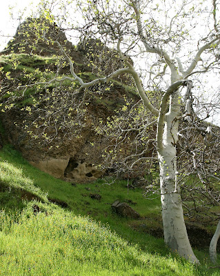
Here's a Sycamore tree up close. The white bark really stands out, as do the green new growth leaves glistening in the sun.
So look closely at this map below. The ranger passed it around along the trail. The black area shows the existing waterways, the San Luis Reservoir, and the Los Banos Detention Dam and reservoir both constructed in 1967. In blue is a separately proposed off-stream reservoir approved in 1980.
 The proposed Los Banos Grandes Reservoir would essentially dam up Menjoulet Canyon and flood the entire Sycamore grove shown above. Ranger Ranc informed us that neither the funding nor the water has become available to move this project forward since it's approval in 1980, so they continue to do hikes up here every spring, walking the same path as the natives and California's first European explorers did.
 A rope helped out with some of the steep slippery stuff. Then we were on our way back up the Los Banos Creek bed to meet up with the rest of the group, eat a quick lunch, then begin the hike back to the boat and back to the boat dock by 3:30. I recommend it for everyone. And while I went along with the ranger's tour, he said that people can hike back to that area with out the boat ride across the reservoir and with out reservations. He said not many people do though because it would require an extensive hike around the reservoir to the other side. So if you missed it this year, you've got something to think about for next spring.