Wednesday, March 25, 2009

the 'Path of the Padres'

I've always been interested in California history. It being a relatively new state in a relatively new country, a lot can be learned by looking back to our recent past. So I try to involve myself in whatever resources that come available that help facilitate learning about our historic area.


One such opportunity is that of the 'Path of the Padres', a moderately strenuous day hike that takes you along the original path that the Franciscan Priests (Padres) used to travel over Pacheco Pass from Mission San Juan Bautista on their way into the central valley. I had heard about the guided hike a few years ago and figured that it was about time to inquire about it, so after googling 'Path of the Padres', a telephone number listed on the city of Los Banos' website came up and I called it. After talking to a ranger I was informed that reservations for the hike (which begin in February) had been all reserved... all except for the day of the 21st of March, which was only two days after I had called. So I told them to hold me a spot. I met the ranger and the group of hikers selected to make the 5 mile round trip, at the boat launch of the Los Banos Creek reservoir at 8:00 a.m. There we boarded a small pontoon boat (The Arroyo Queen) that took us across the small lake where Los Banos Creek flows into the reservoir and our hike would begin. Along the ride we made stops, admired the numerous native waterfowl, and were pulled into a marshy area where the tules had grown and provided areas for animals to hide in.
After the boat ride, we began our hike up along the flood plain of the Los Banos Creek bed. Ranger Richard Ranc, leading the hike, informed us that we were about to cross the site where a sizeable Yokuts Indian village once stood.
Here's that site looking back towards the central valley.

Along the way, Ranger Richard pointed out the various plants and animals along the way. He showed us which ones were edible and were used by the Native Americans, and which ones were poisonous. Above he points to a poisonous plant called locoweed. Apparently, the Spanish named it that after they watched their cows eat it and then watched them go crazy. Now the cows stay away from it and it grows taller than the grass that surrounds it.

It was a beautiful day, the second official day of spring. It started out bright and sunny, then got kind of overcast and spotty through out the rest of the day. The constantly shifting light made it a little more frustrating to photograph considering the bright sunlight makes for a much more vibrant color photograph than does one with diffused grayish light.

Like some of the colors in these lichens on the rock and the petals of the poppy... they would have really popped out if the sun were shining... but being part of a guided hike, I couldn't be having the ranger waiting for me, waiting for the sun to come out... at least not for too long.


The trail started out relatively flat, but we soon entered the narrows of Menjoulet Canyon, formed by the erosion of the layers and layers of uprighted sediments that form the eastern edges of California's coastal mountain range.

This is the area where the creek makes large natural pools and was noted as the area where Padre Arroyo would stop to bathe during his travels between Mission San Juan Bautista and the central valley. These pools in the creek , referred to as 'Los Banos' by the Spanish, is what led to the name of the city of Los Banos. Another poisonous plant, this one some sort of Hemlock, is potentially deadly to humans.A ranger shows off a horsehair worm found inside a pool of standing water. It looks really tangled up right now, but as soon as it was put back in the water it quickly started to untangle itself.
On up Menjoulet Canyon were some really interesting rock formations, like this natural overhang.

Before reaching the terminus of our hike and breaking for lunch, Ranger Richard gave us the option of following him on a side hike up to the tops of the hills overlooking Menjoulet Canyon where we could see the largest grove of Sycamore trees in the entire state.
It was a rough hike straight up 600 ft, especially with my camera gear, but totally worth it. From there we could see the central valley, but we could also see a considerable amount to our west. From the west end of Menjoulet Canyon starts the huge Sycamore tree grove that snakes west towards the coast range.
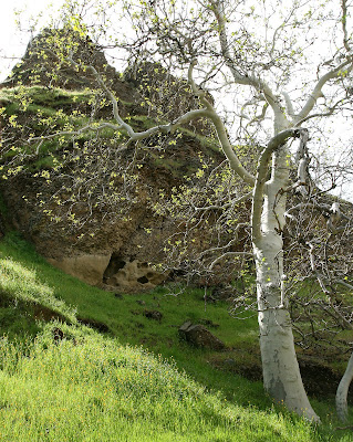
Here's a Sycamore tree up close. The white bark really stands out, as do the green new growth leaves glistening in the sun.

So look closely at this map below. The ranger passed it around along the trail. The black area shows the existing waterways, the San Luis Reservoir, and the Los Banos Detention Dam and reservoir both constructed in 1967. In blue is a separately proposed off-stream reservoir approved in 1980.

The proposed Los Banos Grandes Reservoir would essentially dam up Menjoulet Canyon and flood the entire Sycamore grove shown above. Ranger Ranc informed us that neither the funding nor the water has become available to move this project forward since it's approval in 1980, so they continue to do hikes up here every spring, walking the same path as the natives and California's first European explorers did.

Hiking up steep means you have to hike down steep. If you ever explore this area, I recommend good sturdy shoes that you don't mind getting dirty.
A rope helped out with some of the steep slippery stuff. Then we were on our way back up the Los Banos Creek bed to meet up with the rest of the group, eat a quick lunch, then begin the hike back to the boat and back to the boat dock by 3:30. I recommend it for everyone. And while I went along with the ranger's tour, he said that people can hike back to that area with out the boat ride across the reservoir and with out reservations. He said not many people do though because it would require an extensive hike around the reservoir to the other side. So if you missed it this year, you've got something to think about for next spring.

Monday, February 23, 2009

clearing up the air

around Half Dome that is...I had no idea that one simple photo that took me all of 1 minute to pull over on the side of the road and photograph, was going to cause so much controversy. And not just in the city of Patterson, but apparently in the online communities and blog sites having to do with photography and Yosemite National Park.
The original published photograph that appeared in the Feb. 18th edition of the Patterson Irrigator even prompted another photographer by the name of Tony Immoos, to see for himself if Half Dome is truly visible from the San Joaquin Valley, click on his link to see the product of his efforts... very impressive.

Apparently Tony's quest to find the truth in my photo led him to Denair where he snapped a series of different photos of the alleged dome with different scenes of farmland in the foreground... added proof that I and others are not crazy after all.

--Here's my story. It all started about four years ago when then managing editor of the Patterson Irrigator, Jonathan Partridge, decided to take a hike one day into the hills west of Patterson, namely, 12 miles up off of Del Puerto Canyon road. After climbing up a canyon and reaching a summit, Jonathan received a phone call where folks don't normally receive cell phone reception and continued to talk and talk and talk, until before he knew it, nightfall was before him. He ended up calling emergency services after he got lost, but no one, including a search and rescue helicopter, could find him. Jonathan was instructed to stay put and try to bundle up for the night 'til morning, which he did. In an article that he wrote after his experience, he described the view from the top of the mountain in the morning and said he could see Half Dome from where he was up in the Diablo Range. I, and many others were very skeptical of his description, and from then on I was determined to try and see it for myself.

Sure enough, a few weeks later, a huge winter storm blew through the valley and I figured that of all times, this would be the opportune time to see Half Dome, when the air was clean and clear. I was photographing in beautiful Del Puerto Canyon at the time and still skeptical, decided to climb a nearby hill to get an overlook of the valley. I'll never forget that day when I got that clear look of the Sierra Nevada mountain range and Half Dome... sticking out like a sore thumb! At the time, I was photgraphing with a wide angle lens on 35mm color film, but vowed to one day photograph this elusive phenomenon with better equipment. After returning back to my car and the Interstate 5 Patterson exit, I looked to the skyline and was able to still see Half Dome... in fact I was able to see it half way on my way to Turlock! (And as Tony Immoos has proved from Denair as well)

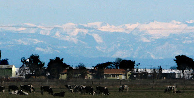
So, fastforward 4 years to Tuesday February 10th 2009. I was running late for a class I'm signed up for at Modesto Junior College when I noticed the elusive Half Dome looming up from a farm off of Jennings rd. I was already late, but I couldn't let it get away from me again, so I pulled over and took a total of 15 frames, the first of which is at the top of this post.

Using the Canon 30D and the 70-200mm f/2.8 lens that I use for work, I focussed on the horizon and took a series of underexposed photos, knowing that it's easier to retain digital information when correcting an image that is darker rather than lighter. The air over the valley was quite clear, but I knew that the image would have to go through some PhotoShop filters and undergo some major cropping before I could even remotely want to have the photo published.

Here's the undoctored original image above.

I zoomed in and cropped it a little.

Cropped it a little more.

Here it is cropped to the original size and format it was when published. I had to use a combination of levels, curves, colorbalancing, and the history brush to get it where it is now.

Here it is cropped in just a little more to really emphasize it's presence. I would have used something along these lines, but I felt that the power line needed to have some context and I chose to include the power pole as well.

While these photos may not be the best photos of Half Dome, I think they clearly show that on a clear enough day, you can see Half Dome with the naked eye from little ol' Patterson. Here's a link to the original blog discussion on a Fred Miranda photography website, thanks Chaz for letting me know.

Thursday, February 19, 2009

Amgen Stage 3 finish in Modesto

I happened to be at the Stanislaus County Library in downtown Modesto Tuesday, working on a research paper for my English class on the Miumne and Hoyumne Yokuts Indians who used to live along the West Side of Stanislaus County until about 1809, when the Amgen Tour of California bicycle race came rolling by.They rode by very fast making two laps around downtown Modesto before crossing the finish line. This year Stage 3 started in San Jose, and much to the delight of a few Del Puerto Canyon residents, avoided traversing Mt. Hamilton and the Diablo Range before entering Modesto.

Even though the canyon and Patterson residents didn't get to see the race this year, so far 875,000 other folks have shown up to get a glimpse of the racers and Tour De France legend Lance Armstrong as he pedals through his comeback year.


Tuesday, January 27, 2009

McHenry ave. Modesto Wal-Mart

Whether you like the idea or not, Wal-Mart has expressed their interest to build what would be the largest Wal-Mart in Stanislaus County... right here in Patterson. These photos are of one of the newest Wal-Marts, the one off of McHenry ave in Modesto. This store is around 120,000 square feet, while the one in Patterson, should it be approved, will be around 158,000 square feet.
Unbeatable?
Lots of room for produce.
At the check out aisle.
Like I said, lots of room for produce, besides all of the other products Wal-Mart normally provides.

Wednesday, December 31, 2008

my top photos of 2008

These were my top choices of photos for 2008. For the full story that accompanied some of these photos in the 12-31-08 issue of the Irrigator, click on the link to the website here.The 2008 AMGEN tour of California pedals through Patterson en route to San Jose via Del Puerto Canyon and Mt. Hamilton.
A pair of Pitman High students ready the arrival of their dairy cows at the Stanislaus County Fair in August.

Family members grieve the loss of their loved ones in a fatal canal accident near Westley that claimed 7 lives and received national media attention.
I took this photo while hiking through Henry Coe State Park in late March, during my attempt to traverse the Diablo Range from Morgan Hill to Patterson.
Patterson's Greg Werne helps rescue thousands of catfish that were pulled up in vehicles by tow truck driver Doug Borges from the Delta Mendota Canal in January.
Lynda Zaragoza is named to the Miss Patterson court during the 2008 Miss Patterson pageant at the Apricot Fiesta.
Torreadors return to Patterson during the Festa de Espiritu Santu's (F.D.E.S.) bloodless bullfight. The bullfighters are all volunteers who chose to enter the ring at their own risk. Some used whatever they could to draw the bull's attention, like this spongebob blanket. I also saw people using umbrellas... it was so cool.
A structure fire off of Loquat Ave. in the Patterson colony, started by scrap metal recyclers using blow torches to retrieve the metal. The structures were total losses.
Some huge windstorms trapped a few Patterson residents' vehicles in late May.
Stanislaus County Sheriff's deputies Eugene Day and Matthew Wagner make a routine traffic stop on Del Puerto Ave. in front of the Total Discount Store.
The Stanislaus County Sheriff's Dive team assesses the recovery efforts that will need to be undertaken to retrieve two vehicles and and the victims trapped in the waters of the Delta Mendota Canal.
Construction slowly continued on the homes at Diablo Grande over the year despite the water woes and uncertainty of the resort's future.
A patch of California Poppies opens for the morning sun near Del Puerto Canyon's historic gateway. One of the largest displays of wildflowers in years could be witnessed over the spring season.
A crop duster crashed in a field off of Marshall road in mid July. The pilot escaped the burning wreck by jumping from the plane as it fell towards the ground. He then hitched a ride back to his car and checked himself into the hospital.
The colors of a setting sunset reflect off of the smooth foundation of the Patterson Business Park's newest building after a Summer storm late in May. The 580,000 square foot McShane Corp building awaits the installation of it's concrete walls, shown in the lower right quadrant of the photo.
Stanislaus County Supervisor Jeff Grover smirks as he listens to the many pleas of Patterson and West Side residents for the county NOT to continue business with West Park developer Jerry Kamilos during a meeting April 22nd. Supervisor Jim DeMartini is seated at his left.
Left over wreckage from the motorcycle that claimed the life of Patterson Planning Commissioner Jim McCluskey as he rode his bicycle along Diablo Grande Parkway in August.
Patterson FFA student Evan Bachelder takes a nap in his pigs' pen after tending to the animals during opening weekend of the Stanislaus County Fair.
San Francisco all girl rock band "Tinkture" plays during Patterson rock festival "Hellapop" in a garage on Ash Ave, along with many many other bands.
A vegetation fire burns 30 or so acres of thick riverside vegetation near Crows Landing August 11th.
Doug Borges of Borges Auto Service, pulls the second of two vehicles involved in a deadly Delta Mendota Canal accident, from the water around midnight. Investigators photograph the scene and cover up the bodies.
Del Puerto Creek west of Patterson flows close to it's highest for the winter/spring season of 2008.
05-26-08--Darrell and 13 week old son Miles Triano reverently visited the various grave sites of those who have served in the name of our nation, after the Memorial day services Monday at the Patterson District Cemetery.
Dominic Verducci ollies the auditorium 10 stair after the last day of school in May.
Eight year old Nicole Ramirez suffers from severe aplastic anemia, a rare blood disorder in which too few red blood cells, white blood cells, and platelets are produced leaving her susceptable to sickness. In order to help prevent further sickness, Nicole is forced to play indoors, but finds refuge in her room where she can play for hours with her dolls and doll house.
Patterson and Central valley residents experienced poor air quality as more than 1,000 wildfires started by lightnign strikes burned in Northern California in late June.
UC Merced Anthropologists and county coroners work to dig up the remains of a 'Jane Doe' buried in the Patterson District Cemetery in 1971 after she was discovered with multiple stab wounds in the Delta Mendota canal. Stanislaus County Sheriffs detectives watch from behind, they hope to use modern technology to help identify the woman and hopefully find the womans' murderer. Later in the year investigators identified the body as San Francisco's Mary Alice Willey.
Homes slowly go up on a terrace on Golf Canyon Ct. in Diablo Grande in March.
Diablo Grande's Ranch Course and tract homes photographed in March.
An empty lot on Foxy ct. in Diablo Grande's custom built estate home sites photographed in October.
Patterson Mayor Becky Campo celebrates her re-election with friends food and drinks at Las Gaviotas Mexican Restaurant on November 4th.
The mood at mayoral candidate Luis Molina's campain party November 4th, was a little more somber as attendees watch the television for updates on the national election results, while Molina checks his cell phone and computer for updates on the local election.
Audiorama plays at the Emulsified Music festival in downtown Patterson October 18th.
Andre Smith from 'Nadine the Band' plays the drums on a closed of section of S. Del Puerto Avenue during the Emulsified Music Festival which featured 16 bands playing live
Farming is still the main activity to occur on the grounds of the proposed West Park inland port site in Crows Landing, as tractors use the defunct airfield as a means to travel between farms.
Record crowds filled North and South Parks over the Apricot Fiesta weekend.
Some friends enjoy the beer garden at the Apricot Fiesta during Friday night of the pageant. Many former and current Patterson residents converge on Las Palmas ave during the extent of the Fiesta to reunite.
Real Estate auction signs and foreclosure notices begin to trickle into Patterson in February.
Police and Paramedics stand watch as the new Mexican restaurant, Hacienda Arteaga, burns in early August.
The concrete walls go up on the 580,000 square foot foundation to Mc Shane corp's newest distribution center building.
The 2008 Miss Patterson pageant contestants take the stage during opening night of the Apricot Fiesta.
Political signs begin to cover the city as election day draws nearer.
Carlos Roque (right) and a woman who wished to remain annonymous, stand beside a roadside memorial put in place by Roque who lost his son to an auto accident six years ago at the same site of Monday night's fatal accident that killed Monica Martinez and three year old son Eloy. The woman, who witnessed the accident and tried to help the dying victims, says she hasn't been able to work for the past few days as the horrific details of Monday night's accident are stuck with her.
Patterson High School campus security Eddie Thompson helps keep students safe at the school in the wake of a gang brawl a year earlier.
Concrete walls go up at Walnut Grove Elementary School's new joint use gymnasium.

Construction continues at Walnut Grove's classrooms.

West Park consultants try to convice Patterson residents about the good things that West Park will bring, during an informational meeting held at City Hall.